OK, it’s been awhile since I’ve posted in this thread, but I’ll move the topic along by going on to the next prediction.
Prediction
4. Except for those areas that were rapidly eroded, and except for the vicinity of the ocean ridges, all of the earth’s surface should be covered with sediments from the flood. This should be especially true in low-lying areas, where sediments would be more likely to accumulate without danger of being washed to a lower level.Test
4. Are there locations in the world, especially low-lying areas, with very different kinds of rocks on the surface? A corollary to this is the question: are there locations in the world in which rocks of the same type can be found on the surface in one location, and closely apposed to the basement (pre-flood) rocks in another location?
First some information about sedimentary rocks:
“The sedimentary rock cover of the continents of the Earth’s crust is extensive, but the total contribution of sedimentary rocks is estimated to be only five percent of the total. As such, the sedimentary sequences we see represent only a thin veneer over a crust consisting mainly of igneous and metamorphic rocks. Sedimentary rocks include common types such as chalk, limestone, sandstone, and shale.” 1
“Sediments form sedimentary rock by compaction and cementation of the particles. Thus, coarse sediments become conglomerates ; sands become sandstone ; and muds become shale . Sedimentary rocks make up only about 5% of all rocks of the earth’s crust, yet they cover 75% of the land area in a veneer that averages 2.26 km (1.4 mi) in thickness, ranging from 0 to 12.9 km (0-8 mi).” 2
“approximately 75% of the Earth’s surface is covered with sedimentary rocks.” 3
“Limestone and chalk are composed of mineral calcite (calcium carbonate). The primary source of this calcite is usually marine organisms.” 4
“The mean sedimentary thickness is 1.8 km on continent (35% of the earth’s surface, and 0.3 km on ocean’s surface). Therefore the average thickness is about 0.8 km which is 4.8 % of the total crust or 0.013% of the whole earth”. 5
“Sedimentary rocks make up only about 5% of all rocks of the earth’s crust, yet they cover 75% of the land area in a veneer that averages 2.26 km (1.4 mi) in thickness, ranging from 0 to 12.9 km (0–8 mi).” 6
4. Except for those areas that were rapidly eroded, and except for the vicinity of the ocean ridges, all of the earth’s surface should be covered with sediments from the flood.
From what I can tell, the areas that are not covered by sedimentary rocks are near oceanic ridges, the shields, and the polar regions.
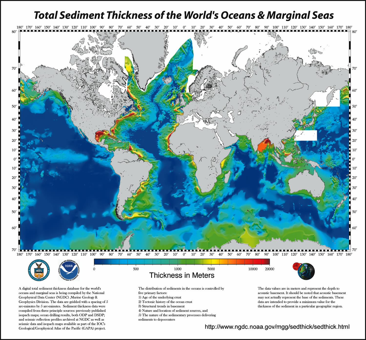
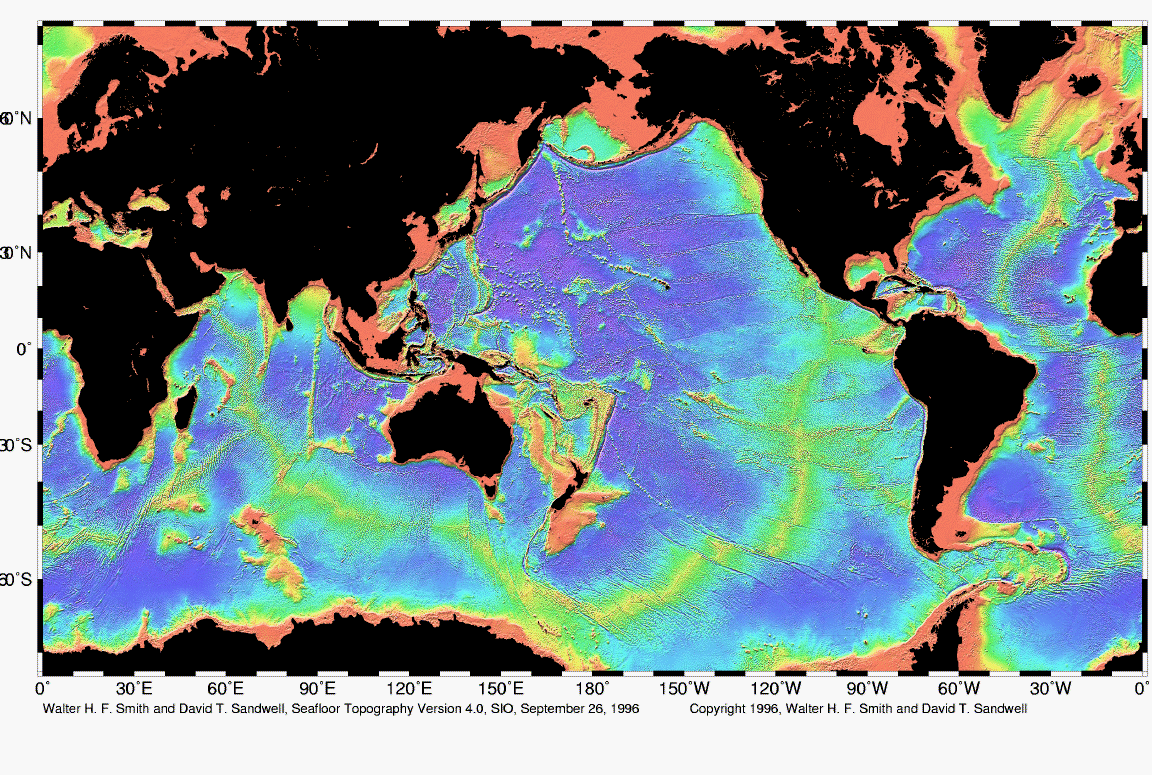
For a diagram of the sediments on the ocean floors, NOAA has a large map in Total Sediment Thickness of the World’s Oceans & Marginal Seas. You can compare the map to a topo map of the ocean floor.
Shields are exposed cratons(basement rocks). One such shield, the Canadian Shield has no sedimentary rocks. 7
The polar regions are covered by ice and obviously doesn’t contain sedimentary rocks on the surface. But, Iceland is an area that also lacks much sedimentary rocks. “Iceland is built almost exclusively of volcanic rocks, predominantly basalts.” 8
One interesting discovery in an Antarctica expedition in 1909, explorers found coal on the Polar Plateau at an altitude of 10,200 feet. 9 How did coal get formed in Antarctica?
Other than these areas, from what I can tell, all of the surface is covered by sedimentary rocks.
4. Are there locations in the world, especially low-lying areas, with very different kinds of rocks on the surface?
One place I found interesting was the Bahamas. The Bahamas is sitting on top of pure limestone.
“The white limestone under the shallow waters is what causes the bright blue halo. The margins of the shelf can drop off steeply, for example on the Atlantic Ocean side (right of the island in this image), a nearly vertical drop to depths of 4000 m explains the thinness of the blue perimeter, while on the western side, the shelf is much wider.” 10 Here is a satellite image of the Bahamas.
“The Great Bahama Bank is a pile of coral reef limestone at least 4500 meters (2.8 miles) thick that has been accumulating since Cretaceous time.” 11
So, here is evidence of one low lying area that has a rock composition vastly different from other areas.
References:
1. http://en.wikipedia.org/wiki/Sedimentary_rock
2. http://www.encyclopedia.com/html/sectio … ryRock.asp
3. http://www.cat.cc.md.us/courses/eas101/ … ntary.html
4. http://en.wikipedia.org/wiki/Limestone
5. http://www.d.umn.edu/~pmorton/geol2300/ … nition.doc
6. http://www.factmonster.com/ce6/sci/A0861014.html
7. http://www.tulane.edu/~sanelson/geol212/sedrxintro.htm
8. http://www.iceland.is/embassy/icelandis … 01454E4700
9. http://www.wonderquest.com/coal-winters … gnoses.htm
10. http://visibleearth.nasa.gov/cgi-bin/viewrecord?12760
11. http://users.unimi.it/paleomag/ambienti … _C-16.HTML
https://debatingchristianity.com/forum/viewtopic.php?p=13054#p13054
Jose wrote:
Given the ages of these rocks, as determined both by measurement of radioactive decay and, independently, by fossil assemblages, it’s clear that there are additional layers of older age that are not found in this location.
I’m not entirely clear by what you mean that there are additional layers that are not found. There are very few places in the entire world where all the layers of the “geologic column” can be found. Missing stratum is the norm.
If your hypothesis is that basement rocks do not have strata, and therefore these metamorphic rocks are pre-Flood, then we’d have to conclude that somehow, during the Flood, something prevented the formation of about half of the strata that we find in other places–the Cambrian through Mississippian formations.
Layering would not be expected to be similar throughout the world by the Flood deposits. So, in the FM, there would not be a global “geologic column” that can be compared with.
Jose wrote:
3. There do seem to be surface rocks of different kinds. The photo of the Bahamas is gorgeous! I wonder…can we wiggle out of this example by considering the fact that much of it is current reef, with limestone-depositing organisms hard at work even as we speak?
One question is how did such a large deposit of limestone get formed? As noted above, it is at least 4500 meters thick. That is quite a large amount of limestone. One would expect that it was formed over a short period of time, rather than accumulated over millions of years. The location is also consistent with the the FM since it is near the coastline (of the US). I would assume the surface of the Bahamas are not comprised primarily of limestone, but sedimentary rocks. So, why would it have accumulated pure limestone over millions of years, then had sedimentary rock on top of that? Also, in what locations of the world do we see pure limestone being formed of such thickness?
Hmm…why might there not be sediments on the cratons? There is a geological explanation, but is there a Flood Model explanation?
I was thinking about this too and I have a theory. From what I can tell, the exposed cratons are primarily in the extreme northern locations. Why would not sedimentary rocks be found on top of it? Sedimentary rocks as proposed by the FM are deposited during the flood. It was a mixture of rocks and water that covered the earth. I theorize that what caused more rocks to settle near the equator than the poles is through tidal forces and the climate change that caused the polar regions to precipitate ice/snow. Through a combination of these two things, less sediments were deposited in the polar regions than near the equator.
I am curious about the uniformitarian explanation to why there are no sedimentary rocks on top of shields. I have tried to find it, but I have not been able to.
To our north, the surface rocks are either hills formed just from jumbled rock and sand, presumed to be the terminal morraines from the glaciers of the ice ages, or flat farmland with a thin layer of what appears to be wind-blown silt. There are no fossils there. to the north of the morraines, we have the craton, with no sedimentary rock at all. These are quite diffferent kinds of suface deposits. What do you make of them?
My guess is that those layers are actually parallel to each other, but all at an incline. The exposed parts on the surface are different layers, much like the diagram of the Boulder area.
https://debatingchristianity.com/forum/viewtopic.php?p=13158#p13158