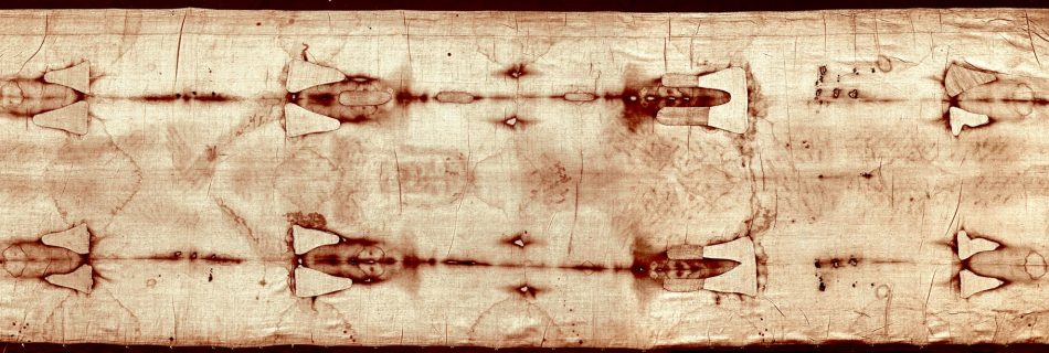
Recovery phase

As the water eroded the sides of the crust, it carried sediments and deposited it rapidly around the world. The entire world was covered with water and sediments at this point. Meanwhile, the crust was gradually settling as the water underneath decreased. As the land mountain ranges were forming and as the sediments in the …

Mountain formation

fried beef sandwich wrote:Just curious, how do you account for the other ridges and underwater mountain ranges besides the mid-atlantic ridge? Actually, practically all the underwater ridges were formed as a result of the crust splitting. So, where you see a mountain range, the crust cracked at that point. As the water gushed out of …

Hydroplate rupture

fried beef sandwich wrote: (1) that there is no evidence of a global catastrophic rupture of water from “subterranean chambers” OK, let’s get into what happened during the flood and we can see the evidence. We all know the idea that the land mass of Europe/Africa and the Americas were once one land mass. The …

Rise of written languages

Another indirect evidence of the date of the flood is the origin of written languages (and oldest civilizations). All written languages came about after 3500 BC. Here is interesting timeline of ancient languages – Ancient Scripts. https://debatingchristianity.com/forum/viewtopic.php?p=3231#p3231

Population growth rate

perfessor wrote: In view of the previous quote, I’m going to ask you to present the “indirect evidences”, and leave the geneology out of it. One indirect evidence is from the population growth equation. The population in 2000 AD has been stated as 6.4 billion. In 1 AD, the population estimates vary from 150 million …

Water canopy

ST88 wrote: Or is the argument similar to the modern idea of a greenhouse effect, with its layer of vapor acting as a uniform insulator around the entire world? As to the actual composition of the water canopy, I don’t know. And nobody can really say for sure. But, my guess is what you described …

Start explaining FM

Before I go in and explain the Flood Model (FM), I will warn readers that what I’m about to share will seem quite far-fetched. But it is only because the Evolutionary Model (EM) has been taught to be a fact and that any other theory besides evolution is plain wrong. So, I ask for a …

Map of erratics

While researching for erratics, I found a nice map showing the location of all the erratics in Willamette Valley. Maps Showing Inundation Depths, Ice-Rafted Erratics, and Sedimentary Facies of Late Pleistocene Missoula Floods in the Willamette Valley, Oregon I think the map also shows that the erosional patterns is not consistent with a flood from …