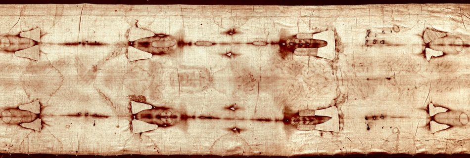
Bretz’s idea rejected

In a series of papers beginning in 1923, J. Harlen Bretz argued the astonishing idea that the channeled scabland and its attributes orginated by stupendous flood, which he called the “Spokane Flood”. This hypothesis sparked a famous and spirted controversy; several rival ideas intent on accounting for the scablands by means other than giant flood …

Basalt pillars

In addition to erratics, there are other rocks standing out, basalt pillars. https://dailyhive.com/seattle/wonderful … r-channels The early evening light casts a warm glow on the basalt pillars of Frenchman Coulee, a popular rock-climbing site, in the Quincy Wildlife Area near Vantage. The unique pillars were formed millions of years ago as lava extruded through the …

Missoula Flood

Ice dam proponents claim that the Missoula Flood occurred many times. Geologists estimate that the cycle of flooding and reformation of the lake lasted on average of 55 years and that the floods occurred approximately 40 times over the 2,000 year period between 15,000 and 13,000 years ago. http://en.wikipedia.org/wiki/Missoula_Floods So, not only did a catastrophic …

Erratics

Let’s look at another interesting anomaly, the erratics. Scattered throughout the Channeled Scablands are boulders of various sizes. Most of them are igneous rocks. But granite boulders of many different sizes are scattered erratically throughout the area. Indeed, they are known as “erratics.” http://www.pbs.org/wgbh/nova/transcript … afloo.html mostly-granite-strewn debris fields over 15 square miles of Rattlesnake …

Wallula Gap could not have existed for 10 million years

It’s typically explained that Wallula Gap existed for at least 10 million years. “Early in the history of folding, the ridgecrest here was slightly lower than elsewhere along the ridge. This caused first the ancient Salmon-Clearwater River (precursor to the Snake River), and then the Columbia River to flow across the ridge over this low …

Wallula Gap dam theory

The Wallula Gap was one of the deepest places during the flood. It is estimated to have been 1250 feet deep. http://www.iinet.com/~englishriver/Lewi … loods.html In the image below, we see erosion all the way to the top of the gap: Yet, it was also one of the narrowest points in which the flood flowed through: …

Curves in erosion

Some more photos to illustrate my points. Again, rushing water strong enough to erode hundreds of feet of solid rock should not leave columns of rock in the middle of the erosion area like this: http://www.iinet.com/~englishriver/Lewi … loods.html And an on rush of water to rapidly erode solid rock should also not exhibit such curves …