Given the photographic evidence of canyons, mountains, buttes, and mesas, I maintain we see a general pattern in the sedimentary rock strata that parallel layers were deposited (with relatively little evidence of any geologic activity) and then after the layers were formed we see massive geologic activity (erosion, faults, mountain building).
The simplest explanation and without the need of ad hoc explanations to account for lack of geologic activity in the layers is not much time passed during the deposition of the strata. That implies all the stratas around the world formed at the same time within a short period. And then after the stratas around the world were laid, major geologic activity occurred.
The question is then what is the mechanism for all of this to happen. I propose the Flood Model is the most likely scenario of what happened.
Here is what I’ve posted before for an overview of the FM:
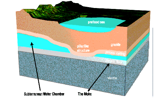
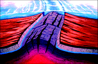
otseng wrote: ↑Sat Aug 04, 2007 10:38 am (The following post is collated from several posts in the Global Flood thread.)Let me start by describing the Earth before the Flood. The earth’s atmosphere was very different than it is now. The temperature was more uniform throughout the earth and was mostly tropical. The entire world was covered by some sort of water canopy which allowed for a global tropical climate. It also did not rain. The earth had an abundance of large animals (dinosaurs) and large plants. The oceans did not exist as we know them now. However, there were seas that existed. The major mountain ranges did not exist and the mountains were smaller than what we have today. About half the water now in the oceans was once in interconnected chambers about 10 miles below the earth’s surface. Europe, Asia, Africa, and the Americas were a connected land mass.
Here is a cross diagram of the earth before the Flood:
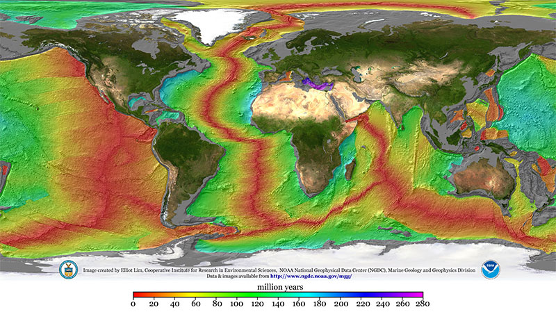
We all know the idea that the land mass of Europe/Africa and the Americas were once one land mass. The commonly accepted idea is that plate tectonics broke up Pangaea over millions of years. There are many problems with this theory. But the most notable one is the existence of the mid-Atlantic ridge. It is the longest mountain range in the entire world. It spans from Iceland to Antarctica (46,000 miles).
Just looking at it, it is exactly halfway between Europe/Africa and Americas. And it looks like this is where the two split. Looking at this, it seems like the E/A and Americas were once joined at the mid-Atlantic ridge, then it got split apart.
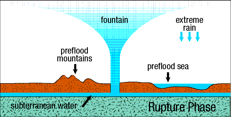
This split occured during the flood. During the initial stage of the flood (rupture phase), the crust split along where the mid-Atlantic ridge is. During the split, the subterranean water gushed out of the crack and eroded the the soil/rock on both sides of the crack. Meanwhile, as water was coming out, the two sides slid away from each other.
The two land masses were not once connected where the beaches are now, but they were connected where the continental shelves are. This explains the origin of the continental shelves.
During the rupture phase as the subterranean water gushed out, the force of the water coming out eroded a lot of the soil/rocks and carried it high into the atmosphere and deposited it rapidly around the world. This destroyed the water canopy that had existed in the atmosphere. The pressure of the water gushing out would have formed the mid-Atlantic ridge.
The major land mountain ranges were formed as the water under the crust diminished. While there was water, the crust was free to move since water has a low friction coefficient. But once the water was gone, the crust hit the basalt underneath. With the large friction coefficient, the crust started to buckle. The crust had a huge lateral momentum as it was sliding away from the mid-Oceanic ridge. The momentum caused the crust to form the Rockies, Appalachians, Andes, Himalayas, etc.
As the water eroded the sides of the crust, it carried sediments and deposited it rapidly around the world. The entire world was covered with water and sediments at this point. Meanwhile, the crust was gradually settling as the water underneath decreased. As the land mountain ranges were forming and as the sediments in the water settled, the water receded into the oceans we have now and also froze in the North and South poles.
The massive amounts of sediments from the crust erosion formed practically all the rock stratas that we see today. So, instead of billions of years for it to form in the EM, it occurred within a year in the FM.
The rapid burial of the plants and animals caused the formation of most all the oil, coal, and fossils we find today.
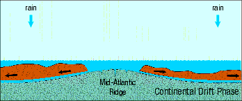
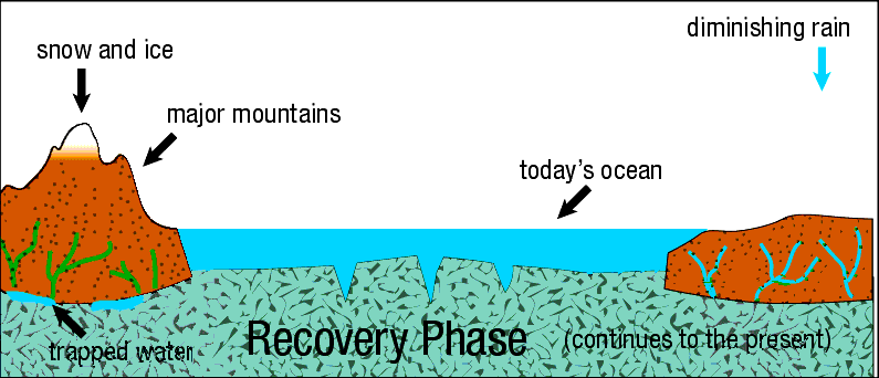
There are 4 major phases of the flood: the rupture phase, the flood phase, the continental drift phase, and the recovery phase.
During the rupture phase, the crack on the crust formed that started at the mid-Oceanic ridge and traveled around the world. Water jettisoned from the underground chamber at the fissures into the atmosphere and eroded the sides of the cracks. I believe this phase occurred over days, perhaps weeks. Brown says this occurred in hours. I however think it must’ve been longer. I think the layers got deposited in stages to account for footprints in layers and also sequences of layers that could not be explained with a single deposit of sediments. Sorting of layers would take place between the stages where deposits were laid down. This entire process could not have happened in hours, but rather over many days.
During the flood phase, sediments and water covered the entire earth. The surface topography was still relatively flat at this point. Brown says this phase lasted months long. I would say this probably last much shorter, in the range of days/weeks. My basis for this is that I don’t agree with Brown on how the mid-Oceanic ridge got formed. Brown believes it was formed by the weight of the continents pressing down on the basalt and it eventually caused the mid-Oceanic ridge to form. I have a different hypothesis. I believe the oceanic ridges were caused by hydrodynamic forces as the water was ejected out of the earth. The pressure of the escaping water would cause the basalt to be forced upward by the water pressure forces and form the ridges. The formation of the ridges caused the flood to go into the next stage, the drift phase. Since hydrodynamic forces would have immediately formed the ridges, the flood phase could not last too long.
During the drift phase, as the mid-Oceanic ridge formed, the hydoplates slid down the ridge and the Americas and Eurasia/Africa moved away from each other. As the hydoplates moved, there was still some underground water under the hydroplates to allow for movement. But, when the water was gone, the hydroplates would stop moving when it hit the basalt underneath. The momentum of the moving hydoplates would cause the formation of the mountains. Brown believes this phase to have lasted 1 day, though I believed it lasted much longer, days/weeks.
During the recovery phase, the water receded into the lower parts of the surface creating the oceans we have now. Canyons were created by water rapidly receding from the areas near mountains. The sea level was lower after all the water receded than compared to now. Over time, all the weight of the continents would cause the continents to gradually sink into the basalt underneath. This would cause the continents to be lowered, as well as push the sea floor up. This would explain land bridges in the past that are now covered by water today.
otseng wrote: ↑Thu Dec 09, 2021 9:58 am I will now present all the questions. SG proponents will answer the questions first and then I will present the FM and answer all the questions. And then we will conclude the flood discussion and get back to the main topic of this thread.How did the sedimentary stratas form?
As we all agreed, all the sedimentary stratas formed underwater.
Where did the sediment come from to form the layers?
The sediments came from the erosion of the continental plates during the rupture of the crust at the mid-oceanic ridges.
Why would layers be parallel?
Non-parallel layers would indicate there was tilting of the layers while the layers were being deposited. Since all the layers are parallel, it would indicate little time passed between the formation of each layer and there was no tectonic activity during the deposition of the layers.
Why is there not an abundance of staggered faults and nonparallel layers in the strata?
There was a small time span during the deposition of the layers and no tectonic activity such as faults or tilting could occur.
If all the layers were formed under water, why is the majority of sedimentary strata now on land and there is practically none in the oceans?
What accounts for the sediment pattern off the coasts in the oceans?
Here is map of ocean sediment thickness. For the sediments that are in the ocean, the majority is off the coastlines.
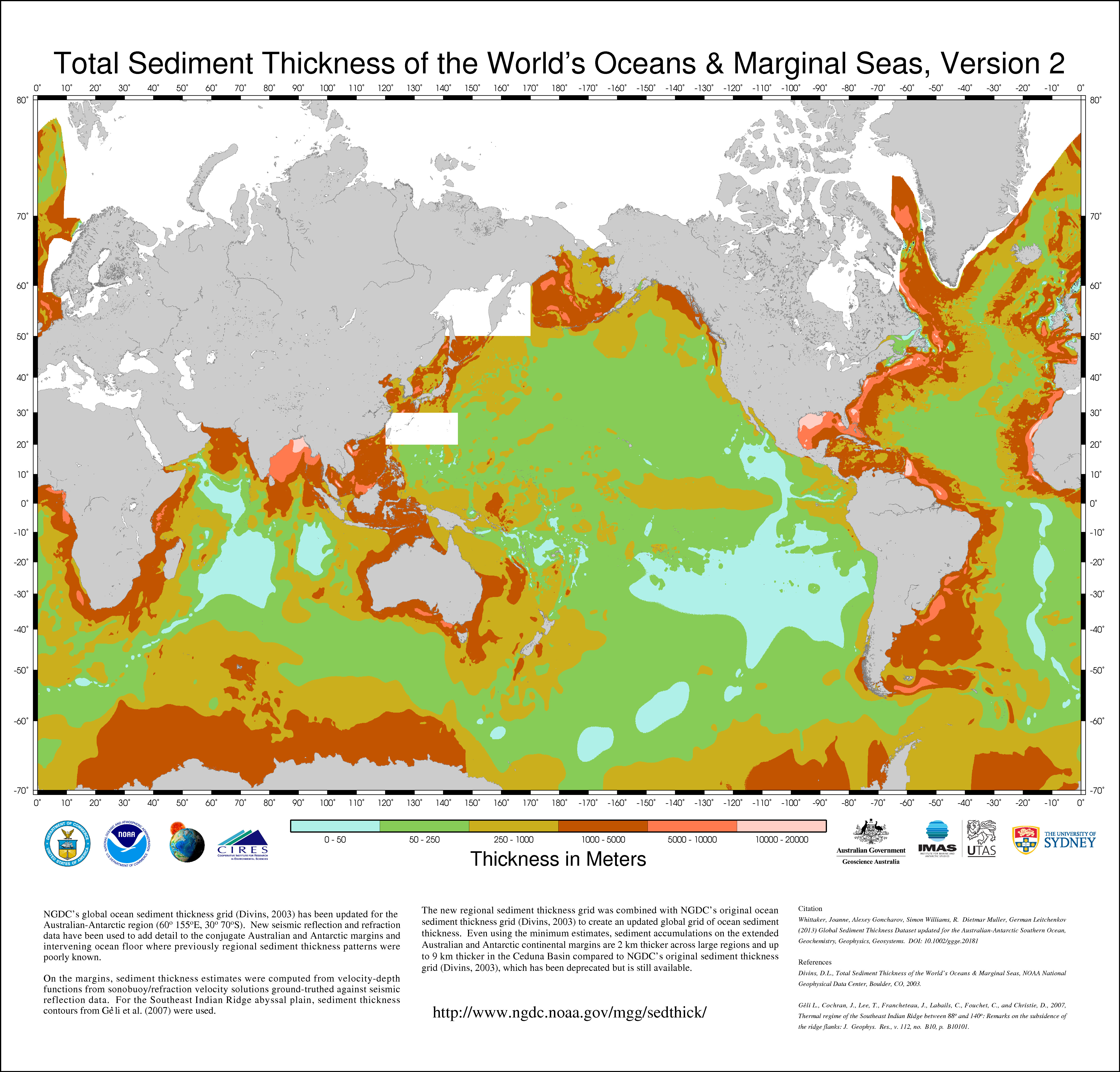
The sediments in the ocean is from the final water erosion from the continents during the recovery phase when the mountains were formed and flood water receded into the ocean.
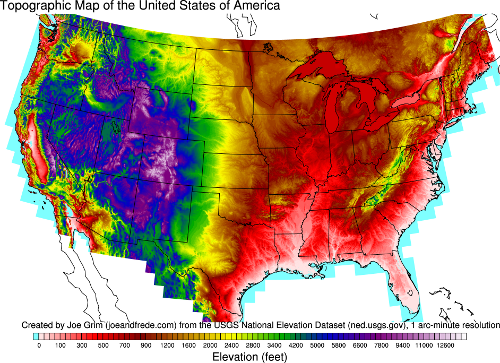
This final water erosion pattern is evident in a topographic map of the US and matches the sediments found in the ocean:
If layers were all formed underwater and since its now above water, how did that happen? Did the land rise or did the sea level fall? How did that happen? Why did that happen after all the layers were formed?
If the sea level fell, how did that happen?
If the land rose, how was it able to rise perfectly for thousands of feet so that it maintained the parallel layers and be parallel to the horizon?
In the FM, the sea level fell due to mountain creation and formation of the oceans between the continental shelves.
Where do we see erosion that has caused flat erosion so that it becomes parallel with the layer below it?
When we see water erosion happening now, do you expect the final result to be a flat strata, or more like a stream/river pattern?
All erosion patterns in the FM are river-like erosion patterns. There are no flat erosions posited by the FM.
Why is there geologic activity (erosion, tilting, folding) on massive scale after all the layers were formed but practically none while they were being formed?
Layers were formed during the flood phase. It occurred on the order of days/weeks, not millions of years.
Why would massive geologic activity only occur after all the parallel layers have been deposited?
Massive geologic activity occurred during the drift and recovery phase.
How can one determine if an unconformity is due to lack of deposition or due to erosion?
Why or how can erosion in an unconformity result in a layer parallel to the one below it?
Unconformities only exist if deep time is assumed to be true.
How can the erosion pattern be explained in Monument valley and surrounding areas?
One thing interesting about the Monument valley area is it could not have been eroded by a river. What else then could have eroded this area? The mechanism is more like a giant bathtub full of water and loose mud at the bottom. And then the plug was pulled out. If you look at a topographic map of the area, the entire region is surrounded by mountains. But, there is one point where the water from the giant bathtub escaped. It is at the Grand Canyon. It was this escaped water from the giant flooded reservoir that carved out the Grand Canyon.
How can the angular unconformity be explained in the Grand Canyon?
The sedimentary layers are formed from rock being eroded at the mid-oceanic ridges. The tilted supergroup formation was formed by erosion of the Pacific ridge west of the American continent. After this strata was deposited, tectonic activity caused the layers to be tilted. Then the layers in the tonto group and above were formed by the continental crust eroded along the mid-Atlantic ridge.
https://debatingchristianity.com/forum/viewtopic.php?p=1059025#p1059025
